Short Manaslu Circuit Trek - 12 Days

Short Manaslu Circuit Trek - 12 Days

48 Reviews in TripAdvisor
52 Reviews in Google

Manaslu region has been largely ignored by development, so remains poor, yet culturally rich. It is superb region above the foothills of the Gorkha District west of Kathmandua. Ethnic cultures, and a trail that puts one physically closer to Tibet than any other trek in Nepal. Short Manaslu Circuit Trek has always seen relatively few trekkers when compared to the more popular regions of the Annapurna and the Khumbu, partly because of the greater logistics required. The quiet trails and simple villages, together with the stunning scenery makes the short Manaslu Circuit Trekking is one of the classic trekking adventures in the Himalaya. 

Trip Facts
Duration: 12 Days
Trip Grade: Strenuous
Country: Nepal
Maximum Altitude: 5106m./16751ft.
Starts: Kathmandu
Ends: Kathmandu
Group Size: 1-16
Activities: Trekking and Adventure
Best Time: March - April and Oct - Nov

Highlights

  • Scenic drive from Kathmandu to Machha Kola, trekking starting point trek of Short Manaslu Circuit Trekking.
  • Immerse yourself in this serene and peaceful environment and experience the Nepalese and Tibetan mixture culture
  • Exploring the Budhi Gandaki River gore, natural scenery, experience local culture and festivals.
  • Captivating flora and fauna - including the possibility of spotting endangered species like snow leopards
  • Trek thought Manaslu Conservaiton Area and explore in less crowded trails in norther Nepal.
  • The highest point on the trek - Larkya La Pass (5,106m/16,751ft) with stunning views
  • Classic circuit trek around the 8th highest mountain in the world and enjoy a closer view.
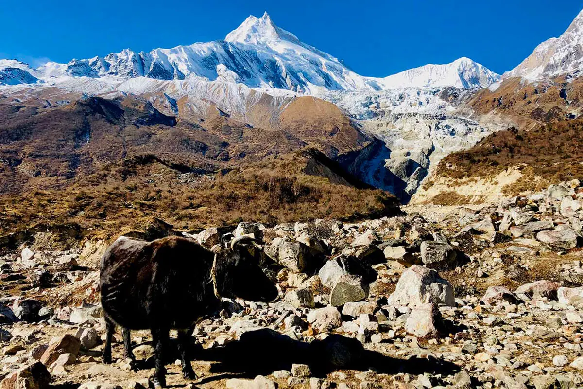
  • Views of highest peaks in the world like Mt. Manaslu, LamjungHimal, Mt. Annapurna II etc.
  • Discover unique moutnain cultural of Hindu’s and Buddhists.
  • Experience the heartwarming hospitality of the locals on the trek.

One of the most well-known treks in Nepal around the eighth-highest Mt. Manaslu ( 8,163 m )in the world. Anyone seeking for a difficult trip in a remote area of the Nepal Himalaya might find this journey appealing. Short Manaslu Circuit Trek is a great trekking route if you are looking for a less crowded option. You will see stunning views of the Ganesh Himal Range and Mount Manaslu while walking through both Hindu and Tibetan-style Buddhist villages.

The 12-day Manaslu Circuit Trek is a transformative journey encircling Mount Manaslu, along newly developed trails that reveal an untouched slice of the Himalayas. This trek offers an extraordinary adventure for experienced trekkers seeking a blend of high mountain challenge, pristine natural beauty, and authentic cultural immersion away from the crowds. It invites you to explore a region where ancient traditions and dramatic landscapes come together in a remarkable circuit.

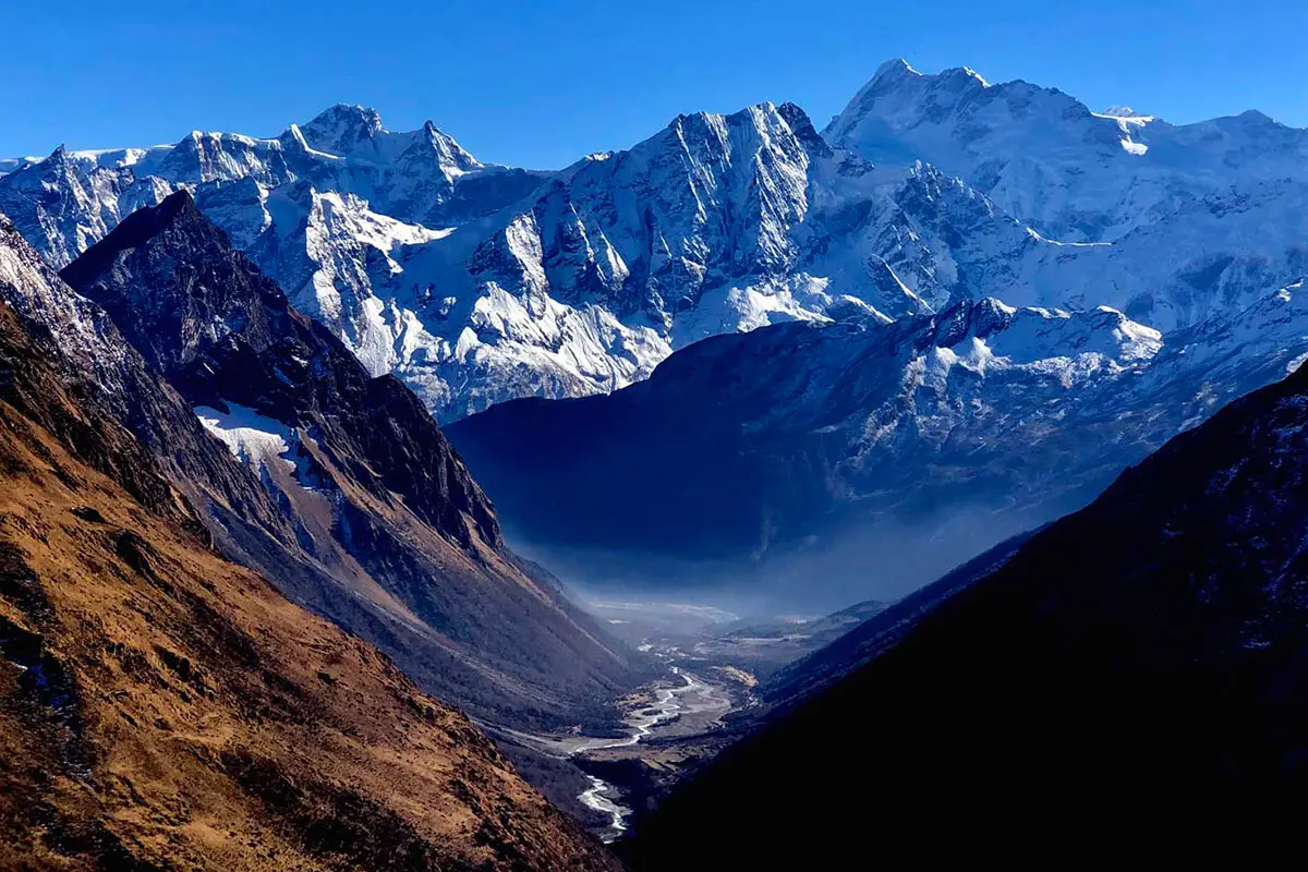
The trek starts with a drive from Kathmandu to the trailhead at Machha Khola, where you’ll gradually ascend alongside the Budhi Gandaki River through traditional villages that offer a glimpse into rural Nepali life. The early stages of the trek traverse lush subtropical forests and terraced fields, where the cultural mosaic of Hindu and local influences is evident. You will pass through forests, ridges, rice terraces, and suspension bridges before reaching Deng, where you'll start to see snow peaks. As you progress, the route reveals a distinct transition into the high-altitude realm of Tibetan Buddhist culture in the upper valleys, with villages (such as Ghap, Namrung, and Lho) which has an incredible viewpoint for Ganesh Himal and Mt. Himalchuli. 

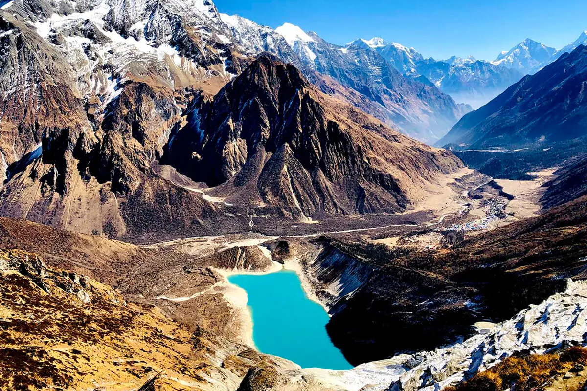
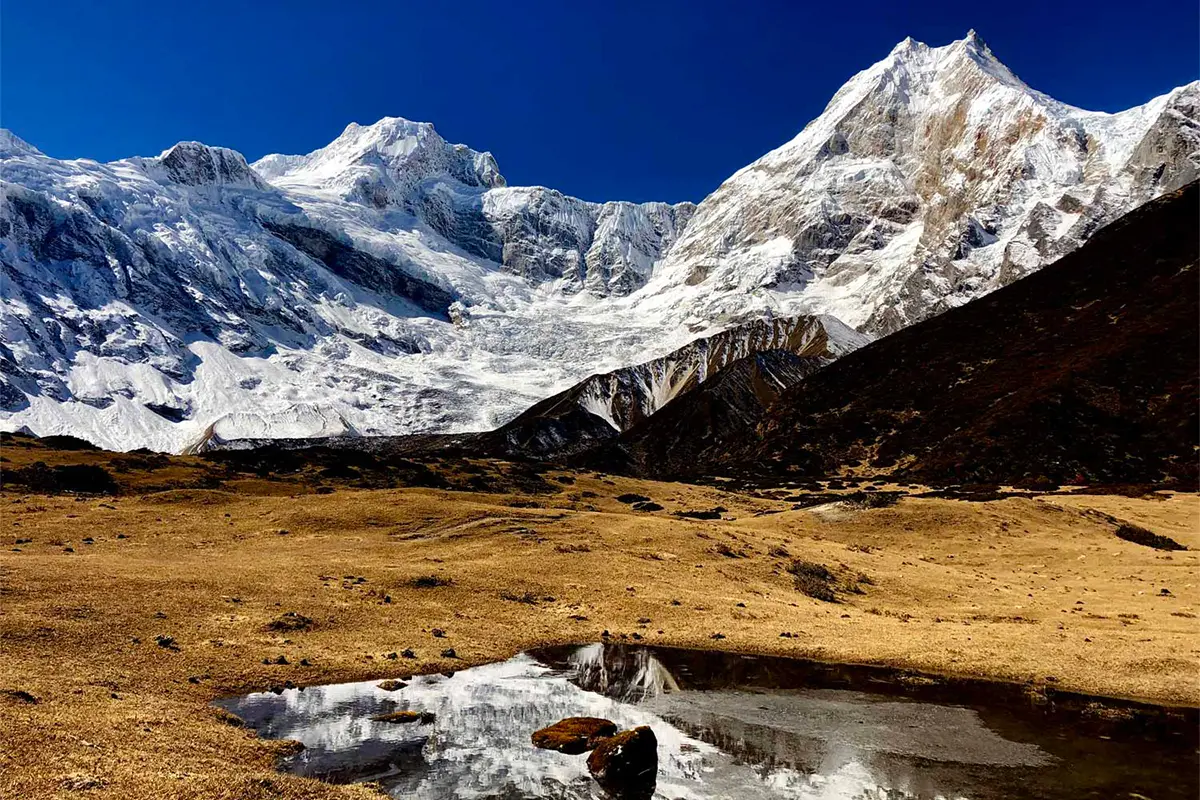
Acclimatization stops at villages like Samagaon and Samdo provide rest and an opportunity to engage with the rich cultural heritage and diverse ecosystems that span from lowland valleys to the highest alpine meadows. The circuit’s heart lies in its dramatic elevation changes, culminating in the challenging crossing of Larkya La Pass at 5,160 m. To tackle Larkaya Pass, you will leave early in the morning from Dharmasala to avoid the strong afternoon wind.

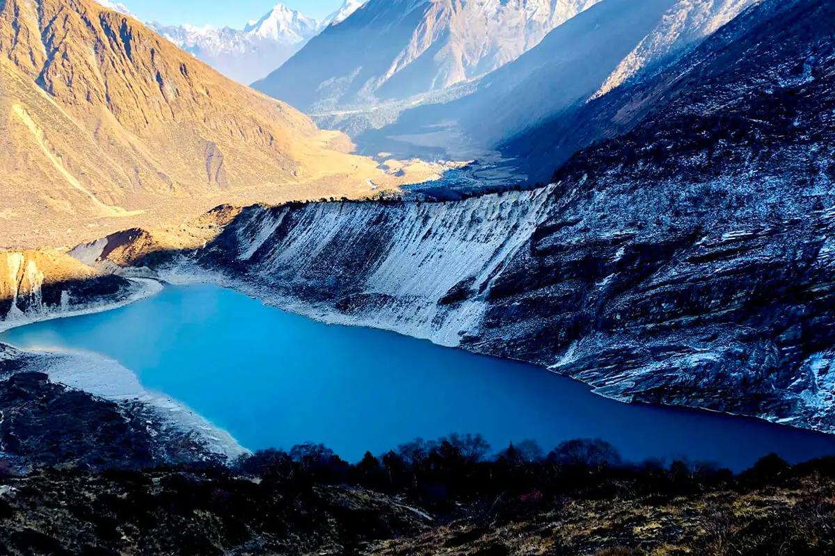
This demanding Larkya La Pass segment rewards you with panoramic views of glaciers, deep river gorges, and the stark beauty of alpine environments. Along the way, key geographical landmarks such as the Budhi Gandaki River gorge and scattered glaciers serve as reminders of the raw power of nature. You will descend through beautiful alpine meadows at Bhimtang. The final leg of the trek leads you through the Annapurna Conservation Area, where the landscape shifts to a dramatically different environment before the circuit concludes at Dharapani. Here, the journey comes full circle as you begin your transport back to Kathmandu, enriched by the unique experiences of a cultural melting pot and spectacular natural vistas. The Manaslu Circuit Trek is the perfect expedition if you crave solitude, challenge, and a taste of authentic Himalayan life on one of the most exhilarating trekking routes available.

Nepal has fascinating trekking options. Anyone may get dubious because of the numerous trekking routes and locations. You must, among other things, be able to distinguish for yourself following, following your preferences and needs. Some places are so fantastic that you must visit them before leaving. Short Manaslu round trekking is one of the best treks preferable for the trekkers who want to enjoy the beauty of Nepal by walking in less-crowded areas rather than the busier Everest Base Camp Trek or Annapurna Base Camp Trek. Although it is gaining the fame of becoming the unexplored, off-the-beaten trail, short Manaslu round trekking offers magical views of Mt. Manaslu, Annapurna, Mt. Hiunchuli, and Ganesh Himal. Trekking Plus special short Manaslu Circuit Trek is suggested for trekkers with physical fitness who can complete the trekking in 12 Days. You can look over Manaslu Circuit 16 Days Trek for the slow with add on few days before and after the Manaslue Circuit Trek. Trekking Plus proposed a budget-friendly trekking schedule for those who desire to travel in a short time to the Manaslu Region. You will get the most amazing possibilities to experience the Himalayas and learn about the same as in Manaslu Circuit Trek, but without spending much money on the short Manaslu Circuit Trek or Manaslu Round Trekking. For any person who thrives on treks to primarily unexplored areas, short Manaslu Round Trekking can be a good choice.

In 1992, Mt. Manaslu (8163m./26,781ft.), the eighth-highest mountain in the world, opened its region to tourists. Manaslu has hosted thousands of people during its thirty years of operations, but this number is insignificant to the trekking regions like Everest or Annapurna. Manaslu Round Trekking presents the most beautiful and lush scenery, vegetation, and mountain views from a farsight and even closer up. However, you will be traveling through an area of Nepal that is off-the-beaten and requires special permits to access. There are particular requirements for trekking in the Manaslu region that restrict the number of tourists who can visit the area. There must be two trekkers (excluding the guide and porter), and the guide's name should mention while obtaining the special permits.  

Itinerary Overview and Route Map

Day 1:Drive from Kathmandu (1,324 m/4,344 ft) to Machha Khola (890 m/2,965 ft), Distance: (160 km / 99.4 miles), about 8-9 hrs drive.
Day 2:Trek from Machha Khola (870 m/2,854 ft) to Jagat (1,400 m/4,593 ft), Distance: 22 km/ 13.7 miles, about 5-6 hrs walk.
Day 3:Trek from Jagat (1,400 m/4,593 ft) to Deng or Dyang (1,860 m/6,101 ft), Distance: 21 km /13 miles), 6-7 hrs walk.
Day 4:Trek from Deng to Namrung (2630m./8626ft.), Distance: 19km./11.8miles, about 7 - 8 hrs walk)
Day 5:Trek from Namrung to Shyala (3500m./ 11480ft.), Distance: 16.5 km /11.8 miles, about 5 - 6 hrs walk)
Day 6:Trek from Shyala to Sama Gaon (3520m./11549ft.), Distance: 17 km /10.6 miles, about 5-6 hrs walk). Side trip to Pungen Gumba (3870m./12696ft.)
Day 7:Acclimatization or Rest Day at Samagaon – Option for side trip to Manaslu Base Camp
Day 8:Trek from Sama Gaon to Samdo (3875m./12713ft.), Distance: 5.7 km/3.7 miles., about 4 - 5 hrs walk)
Day 9:Trek from Samdo to Dharamsala (4460m./14633ft.), Distance: 6.1 km /3.8 miles., about 4 - 5 hrs walk)
Day 10:Trek from Dharamshala to Bhimtang (3590m./11775ft. ) via Larkya La (5160m./16925ft.), Distance: 16 km /9.9 miles, about 7-8 hrs walk))
Day 11:Trek from Bimtang to Tilje Village (2,300 m / 7,546 ft.), Distance: 20 km/12.4 miles, about 5-6 hrs walk )sahar (790 m)
Day 12:Trek from Tilije to Dharapani (1963 / 6440 ft ) about 1:30 min walk and drive to Riepe Village 5-6 hrs drive.

Short Manaslu Circuit Trek - 12 Days Detailed Itinerary

Day 1

Drive from Kathmandu (1,324 m/4,344 ft) to Machha Khola (890 m/2,965 ft), Distance: (160 km / 99.4 miles), about 8-9 hrs drive.

The journey from Kathmandu to Machha Khola is about 160 km, and it takes about 8–9 hours by local jeep /bus. We drive through the paved roads and off-road terrain. While the road offers scenic views, it remains challenging, especially during the monsoon season. Along the way, you will see we will be stopping for multiple breaks and for lunch and stretching. You will enjoy fantastic views of terraced fields, the beautiful Trishuli River, and various Nepali villages as well as beautiful mountain scenery including  Annapurna, Manaslu, Langtang, and Ganesh Himal. Overnight in the lodge at Machha Khola. 

Max Altitude: 890m (2,919ft)
Meals: B,L,D
Duration: 8-9 hrs drive
Distance: 160
Accommodation: Mountain Lodge
Mode of Transportation: Bus/ local shared Jeep
Day 2

Trek from Machha Khola (870 m/2,854 ft) to Jagat (1,400 m/4,593 ft), Distance: 22 km/ 13.7 miles, about 5-6 hrs walk.

We start our day after a hearty breakfast. We will cross a suspension bridge and we move along the way on a rather flat to uphill path. The pathway wound through a deep valley with cliffs where rock formations and waterfalls create a stunning landscape. Khorla Besi to Tatopani is about 30 min walk. Tatopani is a natural hot spring. You may take some time to soak in the warm waters of Tatopani before advancing further to Dhovan Village where we will stop for lunch. Thulo Dhunga to Jagat is mostly uphill for 2.5 hours, which is quite challenging. Most tourists reach Jagat at around 3 pm. Jagat is a beautiful place with an attractions such as Mani walls, Stupas, and traditional houses to explore in the evening.

Max Altitude: 1,400m (4,593ft)
Meals: B,L,D
Duration: 5-6 hrs
Distance: 22 km
Accommodation: Mountain Lodge
Day 3

Trek from Jagat (1,400 m/4,593 ft) to Deng or Dyang (1,860 m/6,101 ft), Distance: 21 km /13 miles), 6-7 hrs walk.

We will leave Jagat after a hearty breakfast. Today is going to be quite exciting, as you can see stunning views and big villages on the way. About 1 hour of hike along the riverbank of Budhigandaki takes you to Salleri. We hike on a jeep route to reach Ghatte Khola and then Philim. Philim is the largest village, and you can visit a big village with a checkpoint for a Manaslu Conservation Area Permit. Also, there are attractions such as hospitals, a gomba and a local school enroute.  About an hour walk from Philim takes you to Chisapani. This is where you stop for lunch for about 1 hour. The final part of the day to Deng is about 4 hours hike that is quite difficult. There are just a few stops, such as Nyak Phedi and Pewa, a small village. Many other locals and mules accompany the uphill hike, as this route also goes to the TSUM valley.

Max Altitude: 1,860m (6,102ft)
Meals: B,L,D
Duration: 6-7 hrs
Distance: 21
Accommodation: Mountain Lodge
Day 4

Trek from Deng to Namrung (2630m./8626ft.), Distance: 19km./11.8miles, about 7 - 8 hrs walk)

After breakfast in Deng, we will begin one of the most important and culturally significant sections of the trek. Cross the Budhi Gandaki and walk up to the bridges, from which we will continue climbing to connect a route from Bhee Phedi. But as you reach Bhee Phedi, things get exciting. This is a beautiful local village with some river, mountain peak views, gumbos, Mani walls, verdant forests, and charming ethnic groups. The final part of the trek takes about 2 hours. The path is initially quite pleasing as you walk on the bank of Budi Gandaki. Then, after crossing the suspension bridge, you go uphill. Walking further passing through Ghap, we will reach another settlement of Namrung.

Max Altitude: 2,630m (8,628ft)
Meals: B,L,D
Duration: 6-7 hrs
Distance: 19
Accommodation: Mountain Lodge
Day 5

Trek from Namrung to Shyala (3500m./ 11480ft.), Distance: 16.5 km /11.8 miles, about 5 - 6 hrs walk)

Today a short walk from Namrung with breathtaking mountain views as the valley unfolds before us. The first two hours of the trek are on a flat path. There are suspension bridges and mountain views of peaks, such as Niki Peak on the right and Lamjung Himal on the left. Rich greens of the lowland valley giving way to the faded browns and grays of its Himalayan topography, and the bright blue skies are experienced at altitude. You get to the beautiful Loo in another two hours where you can see the beautiful Manaslu I and Himchuli as well as some the tranquil Rebung Gompa monastery. We may as well encounter a few yak caravans transporting the timbers while walking through the forest until Shyala. Stay overnight in Local mountain lodge.

Max Altitude: 3,500m (11,482ft)
Meals: B,L,D
Duration: 5-6 hrs
Distance: 16.5
Accommodation: Mountain Lodge
Day 6

Trek from Shyala to Sama Gaon (3520m./11549ft.), Distance: 17 km /10.6 miles, about 5-6 hrs walk). Side trip to Pungen Gumba (3870m./12696ft.)

After enjoying early breakfast, we hike to Pungen Monastery, which is a different route from the Samagaon main route. Our side trip takes about 2-3 hrs of walk.  We hike includes uphill climbing through stone steps and mountain path which is quite challenging. When we are closer to the monastery then its flat terrain and gradual uphill but we can see the breathtaking views of mountains all around. There are also small rivers flowing from the vast grassland of the monastery and Mt. Manaslu looks very close, almost like we can touch it. After a brief moment in Pungyen Gompa, we spent time taking pictures and soaking in the moment. We start our walk back on the same route for 2 hours and take a left to head for Samagaon. Evening you can explore the hamlet and Gombas, a tiny bit of old Tibetan culture. Today we ascent about 539 m/ 98 ft.

Max Altitude: 3,520m (11,548ft)
Meals: B,L,D
Duration: 5-6 hrs
Distance: 17 km
Accommodation: Mountain Lodge
Day 7

Acclimatization or Rest Day at Samagaon – Option for side trip to Manaslu Base Camp

Sama Gaon is our resting place for the day, and our bodies adjust to the altitude. The village offers a variety of day excursions, such as a short hike to the nearby Birendra Tal (lake), or option for the incredibly rewarding and dramatic hiking to Manaslu Base Camp. Samagaon to Manaslu Base Camp Distance: 13.2 km /8.2 miles round trip and total ascent about 1270 m/ 4166 ft
Samagaon is the perfect place for a night’s stay, enjoying a rest day and acclimatization on the Manaslu short trek itinerary. We wake up early in the morning and, after breakfast, start our acclimatization hike. We continue on the Samdo route for 20 minutes and take a left towards Birendra Lake.

Birendra Lake

This glacier lake with pristine blue water from the Manaslu glacier is about a 1-hour uphill hike from Samagaon. This lake is at an altitude of 3,644 meters and gains more than 100 meters when we reach it. This option is good for trekkers who don’t want to or cannot do a strenuous hike to Manaslu Base Camp.

Manaslu Base Camp

If we choose to hike Manaslu Base Camp then we start in the early morning after freshening up and having tea, and we start walking towards base camp. After crossing the river, we climb stone steps going through the forest. The terrain is straight uphill, so in risky areas where the landscape is too steep, there are railings to hold onto and walk. We have our packed lunch on the way after about 2 hours of walking. After 3 hours of walking uphill, we put on our crampons and take out our trekking poles for a strong grip on icy terrain.

View from the top of Manaslu Base Camp is breathtaking, and it is also one of the major highlights of this trek. But trekking to base camp is not fun. It is entirely an uphill trek for about 7-8 hours, gaining 1,200 meters of altitude. It’s an amazing acclimatization hike and only recommended when there is no ice on the way. We return by the same trail, which takes about 3.5 hrs.

Max Altitude: 3,520m (11,548ft)
Meals: B,L,D
Accommodation: Mountain Lodge
Day 8

Trek from Sama Gaon to Samdo (3875m./12713ft.), Distance: 5.7 km/3.7 miles., about 4 - 5 hrs walk)

We wake up and head towards the dining hall for breakfast. Today is the easiest day on our entire trek, as we trek on flat terrain and walk at a relaxed pace. The route to Samdo makes a northerly bend along the upper reaches of the Budhi Gandaki River. Before the final climb to the village of Samdo, you will cross a wooden bridge over the Budhi Gandaki River. Ascending gradually, we reach the town of Samdo after passing past the confluence of the Larke River and the river created by the Samdo Glacier, which is also the source of the torrent Budhi Gandaki. Before that, on our left and in front of the point where we diverge from the route to Manaslu Base Camp, we walk through the lovely Kermo Kharka juniper and birch forests. We continue across wooden bridges and ascend steeply towards the Samdo, where we can see a huge white Kani. We get to our destination after the Kani. 

Samdo Village

This is the last village of Manaslu, which can also be called the forbidden village. It is quite a big village with 30 to 40 local houses, and the people are all Buddhists. Also, there are monasteries and stupas. Right from the hotel window, you can see the beautiful Samdo peak and the entire Manaslu range.

Max Altitude: 3,875m (12,713ft)
Meals: B,L,D
Duration: 4-5 hrs
Distance: 5.7
Accommodation: Mountain Lodge
Day 9

Trek from Samdo to Dharamsala (4460m./14633ft.), Distance: 6.1 km /3.8 miles., about 4 - 5 hrs walk)

We start our trek after breakfast. Today our hiking journey to Dharamshala is relatively short. We follow the path as it passes through the Athahra Saya and Larke rivers. As we travel along the route, we gently ascend, passing through Taka Choeling Gumba with views of Naike and Pangboche Peak. We cross a bridge, walk through the Mani walls with stone houses, and then turn left to reach Larkya Bazaar, a small town with lodging.

Larke Bazaar
Larke Bazaar is the only teahouse at the stop, about a 30-minute hike from Samdo. We crossed a dangerous wooden bridge on the Budhi Gandaki River. Larke Bazaar is a junction of the Tibetan border and Dharamshala.

From Larke bazaar, we hike for another 500 meters on the uphill path, cross the bridge, and head toward the alpine meadow. While enjoying the beautiful view of the Larkya Glacier, we continue towards the stone-built guesthouse in Dharamsala. 

Dharmasala or Larke Phendi

This is the remotest stop on the route, with no village and only three hotels. The rooms are very basic, and you might have to sleep in the common room on a mat on a small wooden platform. Dharamshala or Larke Phedi, the highest point before the Larke Pass, where buildings and tents can be erected. We may see lichened stones, grazing pasture, beautiful trees, and the Syacha Glacier along the way. Also, most tourists go for a few hours of acclimatization hike to Khaki Danda (a 20-minute hike). Here, there is no Wi-Fi, no network, and no electricity. Charging can be done on solar power, which is also very rare.

Max Altitude: 4,460m (14,632ft)
Meals: B,L,D
Duration: 4-5 hrs
Distance: 6.1 km
Accommodation: Mountain Lodge
Day 10

Trek from Dharamshala to Bhimtang (3590m./11775ft. ) via Larkya La (5160m./16925ft.), Distance: 16 km /9.9 miles, about 7-8 hrs walk))

Today is the most challenging day of the short Manaslu Circuit trek. We will hike for about 8 hours. Prepare for a physically demanding day as we travel to Bhimtang via the Larkey La Pass (5160m). We wake up early, freshen up, and begin hiking after breakfast. We arrive at the northern end of the Larkya Glacier after a short ascent and enter a valley with breathtaking views of Cho Danda and Larkya Peak. We take beautiful pictures of the four frozen lakes and hike straight, gaining 704 m, more steeply toward the end of the Larkey-La pass. We stop here for some time to take some pictures with your friends and watch the views of the Himlung Himal (7126 m), Cheo Himal (6820 m), Gyaji Kung (7030 m), Nardi Chuli, Kang Guru (6981 m), and Annapurna II (7937 m). From the top of the Larke Pass, we descend downhill; about 2-3 hrs downhill takes us to a lower altitude Larke Phendi. Be very careful where you place your foot, as the snow can block the terrain or make the trail slippery. From Larke Phedi another 1.5 hours to the beautiful village Bimthang. From the backside, you can see Manaslu, Panchok Himal, and Lamjung Himal. Stay overning in local lodge.

Max Altitude: 5,160m (16,929ft)
Meals: B,L,D
Duration: 7-8 hea
Distance: 16 KM
Accommodation: Mountain Lodge
Day 11

Trek from Bimtang to Tilje Village (2,300 m / 7,546 ft.), Distance: 20 km/12.4 miles, about 5-6 hrs walk )sahar (790 m)

From Bimtang, after an early breakfast, we start our trail by crossing over the side of the moraine and descending to the headwaters of the Dudh Khola, which we cross on a wooden bridge. We continue through the pine and rhododendron woods to Hompuk (3,430m). From the route, you can enjoy the panoramic views of Phungi, Manaslu, Manaslu north peak, Cheo Himal, and Himlung Himal. After walking through the forest trail, we arrive on the road and walk on that for 30 minutes before reaching Goa(2,575m). This is a village of Gurung people where you stop for lunch. The route is filled with ups and downs, passing mostly through the fields but occasionally through dense pine forests. From Goa, we trek for an hour at a relaxed pace on a wide road that take us to Tilije, a multi-ethnic community settlement.

Tilje Village

Tilje village has 30 to 40 houses, both Buddhist and Hindu. It also has a gompa and a health post. There are 4/5 teahouses with Wi-Fi and charging sockets in the room. You can also take a hot shower here, and attached bathrooms are also available.

Max Altitude: 2,300m (7,545ft)
Meals: B,L,D
Duration: 5-6 hrs
Distance: 20
Accommodation: Mountain Lodge
Day 12

Trek from Tilije to Dharapani (1963 / 6440 ft ) about 1:30 min walk and drive to Riepe Village 5-6 hrs drive.

From Tilje we walk about 1.5 hrs to Dharapani and then take a local jeep to Besisahar where we stop for lunch. The jeep ride from Tilje to Besishar is completely off-road about 40-45 km. We stop at Chaymche for a quick break, where we see an iconic waterfall. The drive is around 3.5 hours to Besisahar and then after lunch we drive for about 1.5 hrous to the beautiful Riepe village.

Max Altitude: 1,200m (3,937ft)
Meals: B,L,D
Duration: 4-5 hrs drive
Accommodation: Village Homestay
Are you still confuse from where to start? Trekking Plus has solutions for this.

Cost Details

Includes

  • Transportation from Kathmandu via Arughat to Machha Khola (trek start) and from Dharapani (trek end) to Besishar by local sharing jeep.
  • All standard full-board meals ( breakfast, lunch and dinner - one main course per meal) while you are on the trek.
  • Accommodation during the trek ( we will arrange the best possible mountain accommodation, generally twin-Sharing basis with the bathroom outside).
  • English- speaking Trekking Plus experienced and qualified trek leader (local guide) and porter to carry your luggage. (1 porter between 2 trekkers, porter carry max 8-9 kg per trekker).
  • All expenses of guides and porters (meals, insurance, salary, lodging, transportation, and other necessary equipment).
  • Manaslu special permit with Conservation Area Permit, and Annapurna Conservation Area Permit (ACAP) fees
  • Seasonal fresh fruits every day during the trek and chocolate bars on high passes.
  • Medical kits, including an oximeter to monitor blood oxygen saturation levels in high altitudes
  • Assistance in arranging rescue operation in case of complicated health condition (funded by travel insurance)
  • Souvenir: Company's T-shirt, trekking Maps, Water purification tablets for safe drinking water
  • Farewell dinner in Kathmandu at the end of the trek
  • All government, local taxes, and official expenses.

Excludes

  • International flight airfare
  • Nepal entry visa fees at Tribhuvan International Airport (paid in cash or card)
  • All accommodation and meals in Kathmandu, before and after the trek.
  • Extra accommodation in Kathmandu due to early arrival or late departure, or early return from the trek.
  • Personal expenses such as snacks, boiled water, hot and cold drinks, hot showers, alcohol, Wi-Fi, telephone calls, battery recharge fees, extra porters, etc.
  • Personal trekking equipment.
  • Travel insurance, which has to cover emergency high-altitude helicopter rescue and evacuation in addition to medical expenses (mandatory)
  • Tips for guide and porters (Tipping is expected)
  • Additional costs or delays caused by out of management control, for example, landslide, weather condition, itinerary modification due to safety concerns, illness, change of government policies, strikes, etc.
  • All the costs and expenses which are not listed in "cost includes" will be counted as "Excludes"

Essential Information

Meals during short Manaslue Circuit Trek

Trekking Plus serves Nepalese, Chinese, Continental, Italian and several local cuisines during the trip. Breakfast, Lunch & Dinner are included in the package. Mount Trails guide will suggest delicious, hygienic and each place special food during your trip. Mountain restaurant owner prefer not to order many dishes and waste food as they would like to cater more trekkers with limited food before run off stuck. Its a week or more days hard work to porters and caravans to bring food to these places. During this trek you will usually have breakfast and dinner at the same Lodge, lunch will be eaten at one of the trail side restaurants en-route.

Accommodation while on Manaslue Circuit Trek

During the Manaslu Circuit Trek, we stay in mountain lodge or a teahouses. Private rooms are available in most of the mountain lodges but in high altitudes ones where it will be just common basic rooms. The rooms are on twin sharing basis with twin beds and very little additional furniture. Blankets are generally provided in the lodge but better to have our own sleeping bags. There is a large dining room-cum-lounge, warmed by the bukhara stove (an iron cylinder, fitted with a chimney duct, in which a log fire is lighted. There is normally no electric lighting in the rooms unless the village has hydroelectric power. The dining room usually hassolar lighting. Most teahouses now also have electricity for charging mobile phones and cameras and there may be a small charge for this.

Drinking water

Mount Trails Trekking and Adventures provides Iodine treated water during the trek. All tea houses have mineral water and boiled water for trekkers upon additional cost. We discourage the purchase of Mineral water and bottled water while on the Trek as plastic bottles aredifficult to dispose off and have become an environmental problem

Manaslu Circuit Trek Difficulty

Manaslu Circuit Trek lies in the northern Himalayan range, in the west-central part of Gorkha district. Manaslu Circuit Trekking takes about 17 days on average, but we can make it longer or shorter. The average distance each day will be approximately 15–20 KM, and the time will be about 8 hours each day. The trek can be made longer or shorter depending on the length of your walking days and starting point.

  • You need to be physically and mentally prepared for Manaslu Trekking
  • It is important to train yourself and get used to walking on uneven surfaces in the himalaya.
  • Crossing the Larkya La Pass at an altitude of 5,213 m is the most challenging day during this entire trek. But at the same time, it’s more a test of your patience level.
  • You have to walk on snow, but you don’t need any technical skills to cross this high alpine pass.
  • You will experience more wilderness, remote, and local mountain culture and adventure during Manaslu Circuit trek.

Best time to visit Manaslu circuit trekking

The best time to go on the Manaslu Circuit Trek in Nepal is during the autumn season (September to November) and spring season (March to May). During these months, the weather is mostly dry and stable, with clear skies and great visibility. The temperatures are also pleasant during the day, making it easier to trek.

However, it is important to note that the Manaslu region can be quite cold at higher elevations, so it is important to bring proper gear to stay warm. Avoiding the monsoon season (June to August) is recommended as heavy rainfall can make the trail slippery and dangerous. Similarly, winter months (December to February) can be extremely cold and snowy, making it challenging for trekking.